Philippine Real Estate Tourism Properties For Sale (Private Islands, Beach Resorts, Beach Lots, Private Resorts, Residential Lots, Commercial Lots, Hotels, Condotels For Sale, And More). Contact our BEST PROPERTIES PHILIPPINES Team For More Details. Mobile: +63.9324090469 or +63.9156432031. Email: bestpropertiesphilippines@gmail.com. Web: bestpropertiesphilippines.com. Facebook: Best Properties Philippines
Current project is geared to searching potential investors, buyers or entrepreneurs to turn this island gem into profitable and bustling tourism destination. If you are interested with this project and wish to get more information send an email to ca.anncalantoc@gmail.com.
CARTOGRAPHIC NAME: Medio Island
LOCAL NAME: Panganoron Island (Panganoron being the native word for "sky")
;
AREA: 401,124 sqm or 40.11 ha or 99.12 acres
MAXIMUM ELEVATION: 65 meters above sea level
OTHER PARTICULARS
Medio Island is one of the three islands owned by the heirs of Martin Palacio, whose address is Dalupirit, San Antonio, Northern Samar, Philippines. The two other islands owned by the heirs are Rasa and San Andres Islands. All three islands are in that cluster of islands known since galleon times as Islas Naranjos (Naranjo being the Spanish word for "orange tree"). Medio itself is at the very center of this group of islands, hence it's name Medio, meaning "middle" in Spanish. The whole island group lies at the entrance from the Pacific along the Paso de Acapulco, or San Bernardino Strait. The Pacific Ocean is nearly 10 nautical miles to the ENE. The Naranjos were the watering place and victualing station for the Spanish galleons in olden times on voyage to and from Acapulco.The islands are presently utilized as coconut plantations.
ECONOMIC PROSPECTS
Like its sisters Rasa and San Andres islands, Medio possesses its main assets: clear blue waters and white beaches of fine sand. Its beach is about 200 meters long and 60 meters wide, capped by a gently rolling hill ideal for resort cottages and appurtenances. Mainland Luzon, Samar and Masbate with their airports are only 30 minutes by speedboat and 1 1/2 hour distant by motorboats. With their coral reefs, Medio and sister islands are ideal for scuba diving, snorkeling, sailing, yachting, jetskiing, parasailing and marine life observation. Medio, Rasa and San Andres Islands, are the only remaining islands of economic size with complete privacy in this area of the Philippines. As a base for island hopping, sheltered from the NE tradewinds and SW monsoon; and calm during most of the year, the islands are unsurpassed.
Medio Island has a clean title.
Price: USD$3,000,000
PROJECT SITE DESCRIPTION AND LOCATION
NARANJO ISLANDS
The Naranjo Islands lie 12º 13' North, 124º 02' East in the east central periphery of the Philippine archipelago. This group of islands is bounded by Sorsogon in the North, Ticao Island in the West, Masbate in the Southwest and Northern Samar in the Far East. It is approximately 10 nautical miles from the Pacific Ocean and sits near the entrance along the Paso de Acapulco, otherwise known as San Bernardino Strait.
Naranjo Islands (also known as San Vicente Islands) consist of six islands formed in a circle cluster with Medio Island at the center. The other islands are San Andres, Rasa, Darsena, Aguada and Escarpada. This group of islands lie within a volcanic belt that has been active for the last 5 1/2 million years and stretches from Southeastern Luzon to Southeastern Mindanao. This volcanic belt includes the active Mayon volcano in Albay.
The circular pattern of the islands and the volcanic composition suggests the group represents the remnants of a submerged volcanic cone which may have formed during the last ice ages when sea level was lower. On the other hand, it could have formed underneath the ocean itself. Medio Island, the center of the group of islands, could be the dome of this extinct volcano.
This group of islands have been the last stop for victuals by the Spanish galleons before their long journey to Acapulco, Mexico.
Naranjo Islands previously belonged to the municipality of Capul. It was later transferred to San Vicente when Destacado Island was renamed San Vicente in the early sixties. Naranjo Islands belong to Region VIII and are part of Northern Samar.
The islands are presently utilized as coconut plantations.
In May 2007, REPUBLIC ACT NO. 9458 [H. No. 786] - An Act declaring the island towns of Biri, Capul, San Antonio and San Vicente, all in the province of Northern Samar as ECO-TOURISM ZONES, was passed.
MEDIO ISLAND
Medio Island has many natural assets that would make it an ideal first class island beach resort. It is a 40.1123 hectare island of gently rolling hills, mostly of coconut vegetation and shrubbery. The highest point of the island is on its northern portion with a maximum elevation of 65 meters above sea level.
Medio Island is approximately 1,300 meters long (SW to NE), 550 meters wide at its widest point and some 330 meters at its narrowest portion. It is blessed with 3 beaches that could serve a variety of purposes. Its main or South beach of fine white sand and corals is about 300 meters long and 60 meters wide. The North beach on the opposite side of the island is approximately three quarters long compared to the main beach and is more secluded. The West beach on the far end has a small extended portion on the West side and is about as long as the main beach. It is separated from the main beach by a lava rock formation. This beach has the best coral bed among the three beaches.
The Southern portion of the island has the least vegetation while the Northern part has the most number of coconut trees. Small trees, shrubs and cogon grass also on the North and West side of the island. Volcanic and lava rocks are visible around the islands.
ACCESSIBILITY
Medio Island is best accessible from Manila to Catarman, Northern Samar. It is also accessible from the provinces of Cebu and Sorsogon.
* Philippine Airlines and AirPhil Express flies from Manila to Catarman daily. Cebu Pacific Air and Zest Air flies from Manila to Catarman four times weekly. Flight time is 1 hour and 20 minutes. From the airport a 45 minute land trip to Allen after which a 30 minute speedboat ride or a one hour and a half long ride in a motorized boat to Naranjo Islands will take the guests to Medio Island.
* Cebu has become an international gateway to Japan, Singapore, Brunei, Malaysia Indonesia, Thailand, Hong Kong and Australia. A night cruise from Cebu may be arranged to bring the tourists to the island giving them enough time to rest before indulging in the beaches of Medio Island.
* Manila - Sorsogon may be the longest route (about 12 hours by car or bus) if one travels by land but it is definitely one of the most scenic routes as one passes through the many idyllic towns of Southern Luzon. This route shall allow a short visit to the hot springs in Tiwi, Albay; Mayon Volcano (the volcano with the perfect cone) and the Cagsawa church ruins in Legaspi. The road ends in Matnog, Sorsogon. A ride in a motorized boat may take about an hour and a half from Matnog. For those who would like to take a plane, a Manila-Legaspi flight is available. Travel time is approximately one hour.
ENVIRONMENTAL SETTING
METEOROLOGY
Local Temperature
The climate in the general area of Samar is typically warm and humid. Local land and sea breezes prevent extremely high temperatures at the beaches, so that a maximum often occurs just before the onset of the sea breeze. The minimum temperature is reached just before dawn. Mean annual temperature is 27.5 degrees Celsius and relative humidity is in the low eighties.
Wind Condition
The prevailing winds are the Southwest monsoon which begins about the end of May up to the middle or end of September; and the Northwest monsoon which generally starts towards the beginning of October. The winds are normally light to moderate with an average velocity of about 2 or 3 meters per second (5 to 7 miles per hour).
Rainfall
There is no weather station in Naranjo Islands. The nearest weather stations are in Masbate and Catbalogan, Samar. The weather condition of Naranjo Islands may be an approximation of those of Masbate and Catbalogan. Based on the Philippine Atmospheric Geophysical and Astronomical Services Administration (PAGASA) Climatological Normals Naranjo Islands' annual rainfall is more or less evenly distributed throughout the year and may range from 2,000 mm to 2,600 mm with 35 percent occuring during the months of October, November and December.
Weather Disturbances
Samar has always been mistakenly identified as synonymous to typhoons but the statistics of PAGASA (1941-2001) indicate that Region VIII ranks only 5th among the 13 regions with regards to the frequency of tropical cyclone passage. This may be attributed to the weather station in the East coast of Samar, Borongan, where storms forming in the Pacific are usually monitored. Most of these disturbances usually re-curve to the Northwest and spare the province from the path of the storms. Those that do not re-curve pass through the North and East coast of the province leaving the Naranjo Islands safe from the destructive tracks of the typhoons.
In the area of Naranjo Islands weather disturbances seldom pass through. The surrounding waters of Medio Island are generally calm most of the year although the North beach of the island experiences swells during the Northeast monsoon season. PAGASA data indicate Ticao Island, which is just west of Medio Island, had only one tropical cyclone crossing its general area in the over 50 years.
OCEANOGRAPHY
Current Factors
The declination of the moon primarily dominates the currents in the San Bernardino Strait. When the moon is nearest the equator, two flood and ebb currents occur each day, but as the moon's declination increases there is an increasing velocity in the flood current and a diminishing velocity in the ebb. At the moon's maximum declination, North or South of the equator, the diurnal difference in the ebb current is so great that one ebb entirely disappears and there occurs only but one flood and ebb current in a day. It will be noted that during this time, the flood lasts for the longer time of the day and is of varying strength.
Current Flow in the General Area of Naranjo Islands
The North Equatorial Current approaches the Philippines as a broad West flow across the Pacific. It is stronger during the Northeast monsoon and has an average velocity of 1 knot in the latitude of Samar. The flood current enters the Samar Sea from the North through the San Bernardino Strait at a velocity of about 4 or 8 knots and generally sets Southwest between and around the Naranjo Islands, South between Capul and Dalupirit Islands and South-Southwest between Dalupirit Island and the Northwest coast of Samar.
In the channel between Aguada and Escarpada Islands, the flood current sets Northwest; and between Rasa and San Andres Islands, it sets Northeast. The meeting of the currents causes rips and tides in the area Southwest of the San Andres Island, North of Rasa Island and in the entrance of the passage between Rasa and Darsena Island.
FRESH WATER SOURCES
Aguada Island is the major source of spring water in the area. A large reservoir has been constructed in Barangay Ternate of the same island. Water faucets are strategically located in the small village for accessibility. Medio Island has a deep well but the water needs boiling if it shall be used for drinking. Capul also is a major source of potable water.
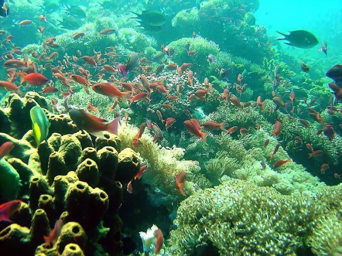
MARINE FAUNA
The waters of Naranjo Islands are rich in marine life due to the strong currents from the San Bernardino Strait. Magnificent coral gardens and tropical fishes abound in the area. One of the investigated area, Binangtan Island off the North coast of Darsena, has the most number of tropical fishes and splendid coral gardens. Hard and soft corals flourish in the area like fan corals, table corals, vase corals, stag horn corals, among others. Moreover, the waters surrounding Naranjo Islands are also considered the game fisherman's paradise where varieties of fishes such as swordfish , marlin, yellow fin tuna and grouper can be caught.
Some areas of Medio have long beds of beautiful corals and an abundance of colorful fishes and marine life. A small portion of other areas have coral reefs with some damage primarily because of blast fishing. Some corals in Medio Island's South beach and some portion of the North beach have been regenerating. The diverse fishes in the area are interesting and fascinating. Local fishermen are selling parrot fishes as large as 2 or 3 kilos a piece and lobsters caught in the area. Sea abalones, large mussels, crabs, oysters and sea urchins abound in the waters of Naranjo Islands.
VEGETATION
The Spaniards named the group of islands "Islas Naranjos" because of the oranges that grew on the island during the galleon days. Unfortunately, the natives did not know how to care for this type of trees and eventually they all died and were replaced by the sturdier coconut trees which are now the major vegetation in the area. Crop planting like rice and vegetables are virtually nil.
WILDLIFE
Naranjo Islands has not much wildlife to speak of. This may be attributed to the lack of fresh spring water in the islands and hardwoods. There are no endangered species that may be dislocated upon the transformation of the area into a tourism zone.
DIVING POTENTIAL OF THE AREA
The diving potential of the area may be gauged primarily from the current movements in Naranjo Islands, its coral beds, adjacent islands with potentially good drop-offs and crystal clear water. The strong currents coming from the San Bernardino Strait would indicate a myriad of underwater life forms in the area. Marine fauna is expected to be abundant and ideal for scuba diving and snorkeling.
At present, there are seven (7) major dive sites in the country. Namely:
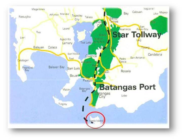
1) Southwest tip of Batangas in the Verde Passage
2) Northern part of Mindoro including Puerto Galera
3) Busuanga area
4) Northern Palawan
5) Tubbataha Reef in the Sulu Sea
6) Cuyo Islands in the Northeast area of Palawan
7) the waters between Negros, Cebu and Bohol
Due to the funnel-like structure of the San Bernardino Strait, current in this part of the Samar Sea could be quite significant. The current flow in some areas of Naranjo Islands may reach about 3 meters per second. Such currents may offer drift diving activities to the more advanced divers. Drift diving could extend a diver's area of coverage and diving time. The waters in this part of the Samar Sea may become the new frontier of the more adventurous diving enthusiasts.
Investigated Area
With only 2 days of diving expedition, the area of the underwater survey was very limited. The first dive was made at the Southern tip of Darsena where a good drop-off is located. The area at the Northwestern side of Medio was surveyed and was found to have a number of interesting underwater caves. A long bed of good corals have also been noted in the area. Plenty of diverse tropical fishes abound. The southwest, East and Northeast areas of Medio have a few broken and scattered corals due to blast fishing. The last area of be investigated was the Binangtan Island in the North coast of Darsena. This has been the best coral grounds so far surveyed. It has the most number of tropical fishes and the largest variety of corals.
Other Possible Dive Areas
The islands in Naranjo are all surrounded by coral reefs and drop-offs. There are more than a dozen potential diving areas waiting to be discovered. The waters of San Andres, Escarpada and Aguada remains unexplored. Some of the possible interesting places are: Budong Point, South end and the Northwestern tip of Escarpada, Caua Point and Samuro Point of Aguada, Southeast and Northwest area and Sallao Point of San Andres, West portion of Rasa and the channel between San Andres and Rasa.
Naranjo Islands are formed in a circular pattern such that one can always find a safe place where the water is calm even during a storm. This unique formation coupled with the numerous diving areas available to choose from make scuba diving relatively a 365 days a year activity.
Diving Precautions
The strong current in and around the islands could pose some danger to the novice divers. An extensive survey of the diving areas must be made to plot, plan and time dives according to the existing current. The underwater caves on the North shore of Medio will be extremely dangerous during strong currents as sucking motions were noticed on the first dive to the caves as flood currents are coming in. Only advanced divers must be allowed to do drift diving activities with strong current flow.
BRIEF HISTORY
Eastern Visayas is one of the most historical regions in the Philippines. It was the site of two events that have influenced the country’s history. The first being the discovery of the Philippines by a Portuguese explorer named Ferdinand Magellan in March 16, 1521 as he landed on Homonhon Island off the southern tip of Samar. The second was the promised return of the American General, Douglas MacArthur, in 1944 in the province of Leyte that liberated the country from the Japanese occupation during the second World War.
The exploits of Magellan encouraged Spain to send in more expeditions and later established the Manila Galleon Trade. The route passes through the Southern coast of Luzon down to the San Bernardino Strait and across the Pacific to the California coast and finally southward to Acapulco in Mexico. These voyages are long and perilous and may take some 200 days or more and provisions are usually acquired where it was available. The “Islas Naranjos” sitting near the mouth of the San Bernardino Strait was the galleons last stop for water and other victuals before venturing out into the Pacific en route to Acapulco.
During World War II, the region became a major zone of the Pacific theater of conflict. Using the same gateway that the conquistadors had taken some 400 years ago, Gen. MacArthur took a gamble and penetrated the center of a Japanese network of airfield and military bases by landing in Leyte to defeat the Japanese army.
Contact our BEST PROPERTIES PHILIPPINES Team For More Details or For Site Viewing Assistance:
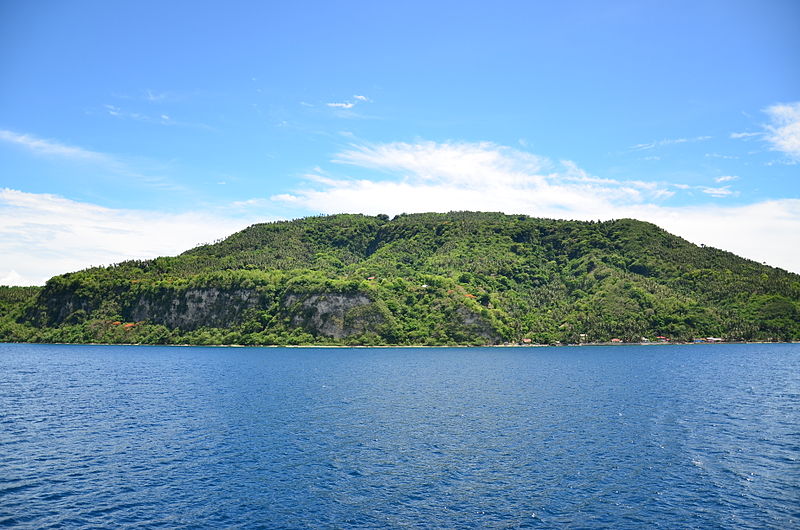
Set in a very rich and well-preserved natural environment, Verde Island Resort is an exclusive high-end residential resort anchored on a world-class, top dive and beach destination that offers a unique vacation experience of exceptional quality. Designed to blend with the island natural beauty, the resort is surrounded by coral sand beaches and turquoise waters and a spectacular coral reef 50 to 300 meters from shore. A 2004 study by members of the Smithsonian Institute indicated that the Verde Island Passage is home to an astonishingly high concentration of marine life making the area one of the top rated dive sites in the world.
PROPERTY DESCRIPTION
The property is 100 hectares of raw land and the existing Verde Island Resort Facilities is 11.4 hectares of beachfront. It is located in an area where the land is generally for tourism, commercial and residential purposes.The 11.4 hectares Verde Island resort currently has existing buildings and developments which include:
Casa Maharlika with 32 rooms that needs repair
Casa Condesa with 12 rooms that needs repair
Main Restaurant/Bar and Main kitchen
Function rooms
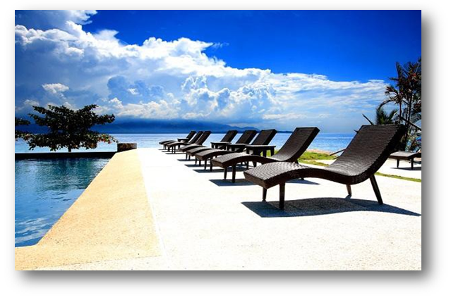
Infinity pools
Pool house
Power house
View deck / Activity area and Walkways
Helipad
Dive site
Bamboo Plantation
LOCATION
Verde Island Resort is located at Sitio Subukin, Barangay San Antonio, Isla Verde, Batangas City, in the province of Batangas in Southern Luzon, Philippines.
Access from Manila via SLEX and Star Toll Connection:
Batangas Port: 1 hour by land and 1 hour by outrigger boat.
Pagkilatan Port: 1.5 hours by land and 20 minutes by outrigger boat.
SELLING PRICE
A.) 100 Hectares Raw Land at Php700 per sqm:
=Php 700,000,000.00 (more or less USD 17.5M)
B.) 11.4 Hectares Verde Island Resort:
=Php 370,000,000.00 (more or less USD 9.25M)
C.) Total Selling Price (A+B):
=Php 1,070,000,000.00 (more or less USD 26.75M)
Note: Based on Cuervo Appraisal Report Dated September 20, 2011.
OTHER FACTS
The 11.4 Hectares Verde Island Resort is owned by a Corporation.
The 100 Hectares Raw Land Property is titled under the same Corporation that owns the Verde Island Resort.
Cuervo Appraisal Reports are available for both properties.
Inspection Report of Verde Island Resort Structure and Utilities is available.
Master Plan of Residential Resort Development for 100 Hectares Raw Land is available and will be handed over to the Buyer upon purchase.
Contact our BEST PROPERTIES PHILIPPINES Team For More Details or For Site Viewing Assistance: